Canal Siltation Study
North by Northeast provided Hydrographic and Topographic data before and after re-grading the canal bottom to re-direct water flow through the canal. Successfully merging mixed data sets (hydrographic and topographic), we obtained good correlation at the respective data boundaries and a computed volume of displaced material that matched the contracted values by -3%.

Shoreline Inventory
Using Ricohs Caplio 500SE Camera with built in GPS and Compass, we acquired photographs of existing use and development of riverside and lakeside shorelines. The photos are readily pulled up in ESRI’s ArcMap software and overlayed onto existing maps with commonly used mapping datums. With PhotoLinks add-in software a thumbnail of the picture is available, as you move the mouse cursor over the picture symbol, for review before loading the full picture into the default viewer.

Right of Way Survey
We recovered and mapped one mile of Metro North Railroad (Connecticut Department of Transportation) right of way to add new electric transmission structures, connecting the new Gas Generation plant on Washington Avenue with CL&P’s substation on Baldwin Avenue in Waterbury. CT. We provided survey services for several phases of the project including; permit maps, conductor clearance surveys, structure stakeout, right-of-way mapping, easement acquisition and as built mapping.

Facility Mapping
Ponomeh Mills is a former textile mill in the Taftville Section of Norwich, CT. The facility contained hydro generation facilities, which were found on multiple levels of the building. When residential development of the site was contemplated, it was imperative for our clients to map their facilities and protect their land rights for access and use of the building for electric generation. A 3D survey of the facility, with extensive use of reflectorless targeting, provided the data to create an comprehensive perspective of existing facilities on the site.

Structural Monitoring
We routinely manage and analyze data captured for deformation studies,including the following tasks: network design and monumentation, establishing observation techniques that create redundancy and thus enable statistical analysis, blunder detection during field observations and post processing, and final report generation.

Laser-Scanning Transmission Towers
We have scanned over 40 Transmission Towers for various Utilities in the northeast and central United States. In most cases the as-built information for the towers is incomplete, and we use the point clouds to model the steel and create 3D drawings of the longitudinal and latitudinal faces, as well as the cross arms and internal sections.
![]()
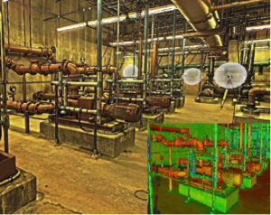
Laser-Scanning Waste Water Treatment Plant
In the spring of 2017 we scanned select interior structures for the Danbury Waste Water Treatment Plant, completing ~130 scans and covering over 40,000 square feet with point cloud data and HDR imaging. The resulting data sets will be used to capture as-built conditions and assist design engineers with re-fitting the site with new or enhanced facilities.